File:Canberra osm development.gif
Jump to navigation
Jump to search
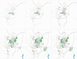
Canberra_osm_development.gif (350 × 404 pixels, file size: 736 KB, MIME type: image/gif, looped, 29 frames, 12 s)
Animated history of the development of OSM coverage for Canberra, Australia.
Contains map data © OpenStreetMap contributors, made available under the terms of the Creative Commons Attribution-ShareAlike 2.0 (CC-BY-SA-2.0).
File history
Click on a date/time to view the file as it appeared at that time.
| Date/Time | Thumbnail | Dimensions | User | Comment | |
|---|---|---|---|---|---|
| current | 04:15, 2 November 2007 |  | 350 × 404 (736 KB) | Latch (talk | contribs) | Updating to include weekly renders since the API 0.5 change |
| 00:51, 4 October 2007 |  | 350 × 404 (609 KB) | Latch (talk | contribs) | Updating to include latest weekly render | |
| 04:06, 27 September 2007 |  | 350 × 404 (573 KB) | Latch (talk | contribs) | Updating to include latest weekly render | |
| 00:39, 20 September 2007 |  | 350 × 404 (536 KB) | Latch (talk | contribs) | Updating animation to include latest weekly render | |
| 07:11, 13 September 2007 |  | 350 × 404 (497 KB) | Latch (talk | contribs) | Updating to include latest weekly render | |
| 00:28, 7 September 2007 |  | 350 × 404 (462 KB) | Latch (talk | contribs) | Updating to include latest weekly render | |
| 10:16, 30 August 2007 |  | 350 × 404 (429 KB) | Latch (talk | contribs) | Updating to include latest weekly render | |
| 03:23, 23 August 2007 |  | 350 × 404 (398 KB) | Latch (talk | contribs) | Updating to include latest render | |
| 00:11, 20 August 2007 |  | 350 × 404 (367 KB) | Latch (talk | contribs) | Added new weekly renders | |
| 00:36, 3 August 2007 |  | 350 × 404 (303 KB) | Latch (talk | contribs) | Updating animation to include more recent weekly render frames |
You cannot overwrite this file.
File usage
The following 15 pages use this file:
- Da:Pick your mapping technique
- Fa:Pick your mapping technique
- Ko:데이터 수집 방법 고르기
- Ms:Pick your mapping technique
- Pick your mapping technique
- Sv:Välj din kartläggningsteknik
- Uk:Оберіть власний стиль мапінгу
- Zh-hant:選擇你的繪製方法
- User:Latch
- DE:Beginners Guide 1.1
- FR:Choisir votre méthode de collecte de données
- ES:Escoge tu técnica de mapeo
- ES:Escoge tu técnica de recopilación de datos
- NL:Pick your mapping technique
- JA:データ収集手法を選ぶ
