Key:building:*
Jump to navigation
Jump to search
| Description |
|---|
| The prefix for several building:* keys to describe additional attributes of a building. |
| Group: buildings |
| Used on these elements |
| See also |
|
| Status: de facto |
| taginfo: building:* |
This page describes a key prefix rather than a simple key.
| Key | Value | Element | Comment | Photo |
|---|---|---|---|---|
| building:colour=* | <RGB hex triplet> | <W3C colour name> | Indicates colour of the building |  | |
| building:fireproof=* | yes | no | Fire-resistance information. |  | |
| building:flats=* | <number> | The number of residential units (flats, apartments) in an apartment building (building=apartments), residential building (building=residential), house (building=house), detached house (building=detached) or similar building. | ||
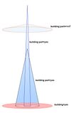
| building:levels=* | <number> | The number of visible levels (floors) in the building as used in the Simple 3D buildings scheme |  | |
| building:levels:underground=* | <number> | To mark number of levels under ground level |  | |
| building:material=* | <material type> | Outer material for the building façade |  | |
| building:min_level=* | <number> | For describing number of values, "filling" space between ground level and bottom level of building or part of building |  | |
| building:part=* | As building | To mark a part of a building, which has attributes, different from such ones at other parts |  | |
| building:soft_storey=* | yes | no | reinforced | A building where any one level is significantly more flexible (less stiff) than those above and below it |  | |
| building:use=* | <use case> | The present type of usage of a building |  |