Proposal:Extended traffic signs tagging/Destination signs
Destination signs
Destination signs specifically are one of the most complex and complete sets of information you can find in a road. It marks the destination, the direction, the way to, the distance...
Nowadays aproximation
Destination sign is tagged as a relation. This is to have unambigous guidance because you mark the roles node by node. But you have to do a relation-per-exit.The keys are destination, distance, time, colour:back, colour:text and colour:arrow.
[Destination as a way] is used to mark the info by lanes or in ways where indicated destinations are identical from all directions.
Alternative aproximation
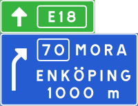
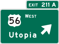
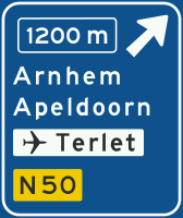
Tagged as a node. With the same scheme of the other traffic signs, including second or third panel. It includes all the elements you can see in the panel , and also all the destinations with the order and the position in the panels as a subtags.
| Tag | Common values | Comment | Example | Image |
|---|---|---|---|---|
| destination:ref=* | * | reference of the destination | destination:ref=5 | 
|
| destination:int_ref=* | * | international reference of the destination | destination:int_ref=E18 | 
|
| destination:upper | * | upper option of destination | destination:upper=Niederbipp | 
|
| destination=* | * | middle or unique option of destination | destination=Colfosco | 
|
| destination:lower | * | lower option of destination | destination:lower=Limon | 
|
| destination:symbol:upper | * | symbol of the upper destination option | destination:symbol:upper=pedestrian | 
|
| destination:symbol=* | * | symbol of the middle or unique destination option | destination:symbol=cafe | 
|
| destination:symbol:lower | * | symbol of the lower destination option | destination:symbol:lower=industrial | 
|
| destination:distance:upper | * | distance of the upper destination option | destination:distance:upper=145 | 
|
| destination:distance=* | * | distance of the middle or unique destination option | destination:distance=6 | |
| destination:distance:lower | * | distance of the lower destination option | destination:distance:lower=679 | 
|
| lanes=* | * | number of the lanes, it is used also for the number of arrows you see at the traffic sign panel | lanes=1 | 
|
| ref=* | * | reference/number of the exit | ref=211A | 
|
| turn:destination=* | * | direction of the arrow in the panel or the panel itselfs | turn:destination=right | 
|
| distance=* | * | distance to the exit | distance=1200m | 
|
| colour:arrow=* | colour=* values | colour of the arrow | colour:arrow=white | 
|
| colour:back=* | colour=* values | colour of the panel | colour:back=yellow | 
|
| colour:ref=* | colour=* values | colour of the reference | colour:ref=blue | 
|
| colour:int_ref=* | colour=* values | colour of the international route | colour:int_ref=green | 
|
| colour:text=* | colour=* values | colour of the text of the panel | colour:text=white | 
|
These are the main tags for the description of the destination signs. Some other keys and subkeys are used to distinguish the differents destination signs if there's more than one.
traffic_sign:x_panel:forward : national ID code for the traffic sign.
| Tag=value | Comment | Example | Image |
|---|---|---|---|
| lower_panel | panel below the main or unique panel | colour:arrow:lower_panel=white
colour:back:lower_panel=green colour:text:lower_panel=white turn:destination:lower_panel=left destination:lower_panel=Basel |

|
| end_panel | panel below the lower panel or at the end side of the panel when there are two exits near each other. | colour:arrow:end_panel=black
colour:back:end_panel=white colour:text:end_panel=black destination:end_panel=Bilbao destination:ref:end_panel=N-634 ref:end_panel=18A turn:destination:end_panel=sharp_right |

|
| main_panel | main panel that shows main destinations at the motorway or at a road | colour:arrow:main_panel=white
colour:ref:main_panel=yellow colour:text:main_panel=white destination:main_panel=Woerden destination:ref:main_panel=N212 turn:destination:main_panel=through |

|
Crossings and roundabouts
With this advanced scheme it is possible to map all kinds of crossings, normal roundabouts , tram roundabouts and turbo roundabouts. Also there is a set of tags for each available direction.
| Key | Derived keys | Direction | Example | Image |
|---|---|---|---|---|
| left=yes | destination:left:lower
destination:left:upper destination:left |

|
destination:left:lower=Santa Isabel | 
|
| sharp_left=yes | destination:sharp_left:lower
destination:sharp_left:upper destination:sharp_left |

|
destination:sharp_left:lower=Burgos | 
|
| u_turn=yes | destination:u_turn:lower
destination:u_turn:upper destination:u_turn |

|
destination:u_turn:upper=L'Arboç | 
|
| sharp_right=yes | destination:sharp_right:lower
destination:sharp_right:upper destination:sharp_right |

|
destination:sharp_right=Allwood Rd EAST | 
|
| right=yes | destination:right:lower
destination:right:upper destination:right |

|
destination:right:upper=Biel | 
|
| slight_right=yes | destination:slight_right:lower
destination:slight_right:upper destination:slight_right |

|
destination:slight_right=Atlantis | 
|
| through=yes | destination:through:lower
destination:through:upper destination:through |

|
destination:through:upper=Indre - Basse Indre | 
|
| slight_left=yes | destination:slight_left:lower
destination:slight_left:upper destination:slight_left |

|
destination:slight_left:upper=Ring road | 
|
| tram_right=yes | destination:tram_right:lower
destination:tram_right:upper destination:tram_right |

|
destination:tram_right:symbol=motorway | 
|
| tram_through=yes | destination:tram_through:lower
destination:tram_through:upper destination:tram_through |

|
destination:tram_through=Gross-Köris | 
|
| tram_left=yes | destination:tram_left:lower
destination:tram_left:upper destination:tram_left |

|
destination:tram_left=Oude Maas | 
|
| tram_stop_left=yes | destination:tram_stop_left:lower
destination:tram_stop_left:upper destination:tram_stop_left |

|
destination:tram_stop_left:symbol=center | 
|
| colour:text=* | colour:text=* | |||
| colour:arrow=* | colour:arrow=* | |||
| colour:back=* | colour:back=* |