Tag:hazard=school_zone
Jump to navigation
Jump to search
 |
| Description |
|---|
| An area near a school where special traffic laws apply. |
| Group: hazards |
| Used on these elements |
| Requires |
|
| Useful combination |
| See also |
| Status: approved |
| Tools for this tag |
|
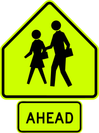
A school zone is an area near a school in which special traffic laws apply. Motorists are advised via signage to reduce speed and watch for the presence of schoolchildren in the roadway.
How to map
This tag should be applied to the stretch of highway=* for which the school zone applies.
Consider adding maxspeed:advisory=* for a displayed advisory school zone speed, or maxspeed:conditional=* for a displayed time restricted but enforced school zone speed, where applicable.
Signage examples
The tables below show what school zone signage looks like in various countries.
| Argentina | Australia | Belgium | Brazil | Canada | Canada (Ontario) |
Canada (Quebec) |
Chile | Colombia |
|---|---|---|---|---|---|---|---|---|

|

|
 
|

|

|

|

|

|

|
| Indonesia | Ireland | Jamaica | Japan | Liberia | Malaysia | Mexico | Netherlands |
|---|---|---|---|---|---|---|---|

|

|

|

|

|

|

|

|
| New Zealand | Panama | Peru | Philippines | Thailand | USA | Uruguay |
|---|---|---|---|---|---|---|

|

|

|
 |

|

|

|