Template:Sv:Tag:highway=pedestrian
Jump to navigation
Jump to search
Exempel
| Foto | Taggar | OSM-Carto |
|---|---|---|

|
highway=pedestrian name=Lloydpassage |
 |

|
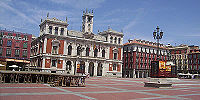
highway=pedestrian area=yes name=Weyher Marktplatz place=square | |

|
highway=pedestrian access:conditional=delivery @ (00:00-11:00) bicycle=yes |
— |

|
highway=pedestrian name=The Moorings motorcar=destination motorcycle=destination |
— |

|
highway=pedestrian noname=yes Sådana fall kan också märkas som en gångväg eller en stig, beroende på lokalsamhällets standarder |
https://www.openstreetmap.org/#map=19/50.09722/19.97816 |

|
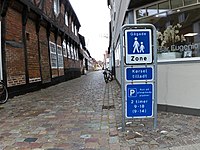
highway=pedestrian name=Fiskergade vehicle=yes note="Gågade" Pedestrian street with "Kørsel tilladt" vehicles allowed. Driving is allowed here, but (tourist)pedestrians are prioritized higher, so motorists basically can't expect to move faster than the pedestrian in front of them. Liknande med highway=living_street, men något striktare för fordon. |
This table is a wiki template with a default description in English. Editable here. Den till svenska översättningen av mallen kan redigeras här.