Template:Zh-hant:Map Features:railway
Jump to navigation
Jump to search
=== 鐵路(railway) ===包含各種經常使用到廢棄的鐵路線路。詳見Railways來了解如何使用。
| 關鍵字(key) | 值 (value) | 元素 (element) | 描述 (desc) | 地圖中呈現 (render) | 照片 (photo) | |
|---|---|---|---|---|---|---|
軌道 | ||||||
| railway | abandoned | 原有的鐵路已經廢棄,而軌道和設施已被拆除,但仍殘留路堤、橋樑、橫斷、隧道等可被辨識。 |  | |||
| railway | construction | 興建中的鐵路。詳見未來功能Proposed_features/Construction中的construction=*和construction=yes。 |  |
 | ||
| railway | proposed | Railway being proposed but haven't started construction. Please see the proposed page regarding verifiability on the ground of this value. | ||||
| railway | disused | 已停用但軌道和設施依然保留的鐵路。詳見disused=yes另一種標示方法。 |  |
 | ||
| railway | funicular | 纜索鐵路。在許多情況皆作為觀光用,給遊客簡單的方式觀賞山景。 |  |
 | ||
| railway | light_rail | 輕便/輕軌鐵路,通常為近似路面電車(tram)但有專用路權(right-of-way)的鐵路系統,如台灣的輕軌捷運及香港的輕鐵系統。 |  |
 | ||
| railway | miniature | 迷你火車,有比窄軌更窄的軌道搭載乘客。 |  |
 | ||
| railway | monorail | 單軌鐵路,如沖繩那霸電車、重慶軌道交通等。 |  |
 | ||
| railway | narrow_gauge | 窄軌鐵路,像是台灣的產業鐵路(糖鐵、阿里山森林鐵路)。使用gauge=*來詳細描述軌距。 |  |
 | ||
| 保存鐵路,即因其歷史價值而保留,並常有具歷史象徵性火車行駛的路線,如台灣舊山線。 |  |
 | ||||
| railway | rail | 路軌。一般的鐵路(重鐵),也可適用於高鐵。 |  |
 | ||
| railway | subway | 適用於台灣的捷運或其他地區的地鐵。詳見城市軌道交通系統(維基百科條目)。 |  |
 | ||
| railway | tram | 路面電車,常和道路共用路權行駛,如香港電車系統。(其他語言) |  |
 | ||
附加功能 | ||||||
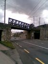
| bridge | yes | 用來跨越其他道路或水路的橋樑。 |  |
 | ||
| cutting | yes | 地塹。即為鐵路軌道比地面還低的地方。 |  | |||
| electrified | contact_line rail yes no |
contact_line: 使用架空線供電。 rail: 使用第三軌供電。 yes: 純粹標記已電氣化。 no: 標記尚未電氣化。 |
 | |||
| embankment | yes | 路堤。即為鐵路比地面還高的地方。 |  | |||
| embedded_rails | yes / <type of railway> | Specifies that a highway on which non-railway traffic is also allowed has railway tracks embedded in it but the rails are mapped as separate ways. |  | |||
| frequency | <number> [Hz] | 使用於電氣化鐵路的電頻,使用0為直流電。詳見電壓標籤。 |  | |||
| passenger_lines | <number> | Used to describe number of tracks of the railway line a certain track segment belongs to. | ||||
| railway:track_ref | <number> | Track number |  | |||
| service | crossover | Relatively short lengths of track which switch traffic from one parallel line to another | ||||
| service | siding | 側線/專有聯絡線,用於連接軍事基地或工廠。 |  |
|||
| service | spur | 支線/分離路線,頭尾連接主線。可用於車站站場。 |  |
 | ||
| service | yard | 用於劃分鐵路機廠區域。 |  |
 | ||
| tunnel | yes | 隧道,地鐵和捷運路線之大部份路段屬於此類。 |  | |||
| tracks | <number> | 軌道數量。因複線通常會以在地圖上直接繪製多於一條軌道顯示,故此標籤並不常用。 |  | |||
| usage | main branch industrial military tourism scientific test |
main line: 鐵路主線 branch line: 鐵路支線 industrial: 工業用支線 military: 軍用支線 tourism: 觀光用鐵道 |
||||
| voltage | <number> | 電氣化鐵道所用電壓。同見電頻標籤。 |  | |||
車站和招呼處 | ||||||
| railway | halt | 招呼站,除非有乘客不然不會停車。 |  | |||
| public_transport | stop_position | 用來標示列車停靠月台的位置點。在數個短節列車停靠在同一條長月臺上很好用。 |  | |||
| public_transport | platform | 鐵路月台。可以用highway=footway來標示月台的連通道。 |  | |||
| railway | platform | 鐵路月台。和public_transport=platform併用。 |  | |||
| public_transport | station | Railway passenger-only station. |  | |||
| railway | station | 鐵路車站。(其他語言). |  | |||
| railway | stop | Marks the position where trains stop at a station. It should be added as a node on a railway=rail way. |  | |||
| railway | subway_entrance | 地鐵或捷運車站之出入口。 |  | |||
| railway | tram_stop | 路面電車、輕軌車站。 |  | |||
Infrastructure | ||||||
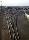
| landuse | railway | 鐵路或鐵路車站用地。 | 
|
 | ||
| railway | buffer_stop | 止衝擋。通常使用在鐵路末端,防止列車超越軌道範圍而出軌。詳見Buffer_stop(維基百科條目) |  | |||
| railway | crossing | 人行道和鐵路交叉處。 |  | |||
| railway | derail | 出軌器,用來防止失控列車或無人駕駛的列車繼續在軌道上前進的裝置。詳見Derail_(railroad)(維基百科條目) |  | |||
| railway | level_crossing | 鐵路平交道。 |  | |||
| railway | railway_crossing | 鐵路和鐵路交叉。 |  | |||
| railway | roundhouse | 扇形車庫。詳見roundhouse(維基百科條目) |  | |||
| railway | signal | 鐵路的行車號誌。 |  | |||
| railway | switch | 轉轍軌。 |  | |||
| railway | tram_level_crossing | A point where trams and roads cross. |  | |||
| railway | traverser | 切換機車頭的地方。 |  | |||
| railway | turntable | 轉車台。用來調換車頭方向。 |  | |||
| railway | ventilation_shaft | A structure that allows ventilation in underground tunnels |  | |||
| railway | wash | A railroad carriage/car wash | 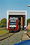 | |||
| railway | water_crane | A structure to deliver water to steam locomotives | 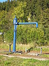 | |||
| railway | 使用者自訂 | 到Taginfo查詢常用標籤值 | ||||
This table is a wiki template with a default description in English. Editable here. 此表格由模版自動生成,協助改善中譯版本請按此。


